There are few trees throughout Europe as characteristic and symbolic as the chestnut tree. And they can be squeezed so much: it gives fruit (it’s time and they are prepared in a flash in the airfryer), it gives wood, it serves as fuel and, of course, it decorates forests and urban parks.
The history of its distribution is so extensive that it has been lost in the mists of time and although its spread is historically attributed to the Romans, the fact is that it was present in most of Europe before the last glaciation, and when it was most widespread in the Middle Ages it was in mountainous areas unsuitable for agriculture as a grain substitute. That’s why This map of chestnut tree distribution It is not limited to ecology, it is also a map of human history.
Knowing where the chestnut tree is native to and where people have planted it helps preserve its genetic diversity and protect it from threats such as canker (a disease caused by a fungus) or crossing with Asian species. In addition, its forests are on the Habitats Directive’s list of habitats of European interest, which requires member states to designate areas for their protection. However, its future with climate change is uncertain and a poisoned candy: while it continues to expand its borders, models projected for the Iberian Peninsula point to a reduction of areas suitable for its existence, especially in the Mediterranean strip.

Distribution map of chestnut trees in Europe
The map was created within the chorological map data set for the main European wood species and is based on national forest inventories, literature, field observations and expert judgement. The legend is simple: the color green corresponds to the likely local area and orange, which was introduced and naturalized from the Neolithic. Both colored “x” correspond to isolated populations.
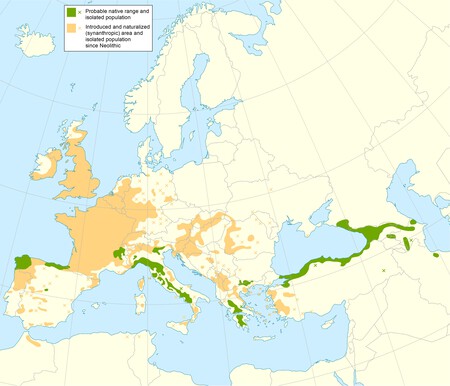
Distribution Map of Castanea sativa (Sweet Chestnut)
Local areas are particularly interesting: Scattered patches in the Iberian northwest (Galicia and the western Cantabrian coast), a western Pyrenean strip, the western and southeastern Alps, the arc of the Italian Apennines, the southern Balkans (Pindo, Peloponnese and Chalkidiki) and a long border south from Annalia. Caucasus.
It should be remembered that this tree survived the last ice age, so its territory was reduced as the cold weather progressed and they were limited to a few climatic shelters in the south of the continent. The European Forest Genetic Resources Program explains that the chestnut tree probably repopulated the continent from refugees, especially from Turkey.
The introduced and naturalized area dominates the central and western continental regions: almost all of France, the United Kingdom, the Rhine valley and central Europe, the Balkans, islands such as Corsica, Sardinia and Sicily, as well as a certain area of North Africa. Isolated populations are particularly numerous in Germany, Central Europe and the Mediterranean. What about the Nordic countries or the Orient? Climate limits its presence: it is a tree from temperate climates, with abundant rainfall and no prolonged drought.
In Xataka | Three trees, 30% shade, a park 300 meters away: formulas that suspend many Spanish cities
In Xataka | Half of Spain on track to become desert: European desertification map warns experts
cover Caudullo, G., Welk, E., San-Miguel-Ayanz, J. Chorological maps for the main European wood species.